OF THE CRATERS OF THE MOON
K.E. Kozubskiy, K.I.Dekhtyareva, T.F. Smolyakova, L.I. Tishik, E.A. Fedorova
Coordinates, diameters and morphological features of 14 923 craters of the Moon in diameters 10 km and more are available in the catalogue.
The catalogue is available for download
in text format: SAI_moon.zip
and in Excel format SAI_moon_xls.zip
Morphological crater classification
A lunar morphological crater catalogue was compiled by the Sternberg State Astronomical Institute in collaboration with the Unified institute of Nuclear Research, Dubna. The catalogue includes data on the coordinates and morphological features of all craters over 10 km diameter over the whole lunar surface. This is the first such detailed compilation of nearly 15,000 craters. 20 years have passed from the time of publication of the best current catalogue, The system of lunar craters [1], covering craters over 5.5 km diameter on the near side, and prepared by the Lunar and Planetary Laboratory of Arizona University. In addition to coordinates and diameters, catalogue [1] gave information on the preservation state, the type of underlying surface, and the presence of central peaks. In our catalogue, each crater is classified according to nine criteria:
1. the rim degradation state
2. the presence of terraces and slumping on the internal slopes
3. the external rim character
4. the presence of central peaks, ridges and mountains on the floor
5. the presence of chains and fissures
6. the character of the floor
7. the presence of lava on the floor
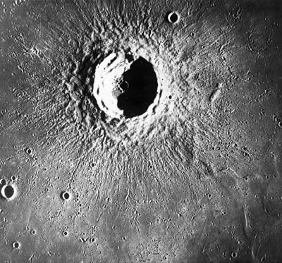
8. ray systems
9. the character of the underlying surface
The determination of the morphological features was carried out based on the visual analysis of more than a thousand images of the lunar surface, obtained from Earth-based telescopes and spacecraft. Each feature is classified into one of several subcategories (see table). As in [1], the rim degradation state is classified into 5 states, but the definition of these states differs slightly. Craters of the first class have a sharp, well-defined rim; those of the second are also well-defined, but less expressed; those of the third have a smoothed rim; of the fourth a partially collapsed rim; and of the fifth, a fully-collapsed rim.
| Feature | No. | Abbreviation | Catalogue code | Indication |
|---|---|---|---|---|
| Rim degradation |
1 2 3 4 5 |
1 2 3 4 5 |
1 2 3 4 5 |
Very sharp rim Sharp rim Smoothed rim Partially collapsed rim Fully collapsed rim |
| Terraces and slumping |
1 2 3 4 5 6 7 |
- Н Т О ТО ТТ ТТО |
0 1 2 3 4 5 6 |
No terrace Unclear Terrace Slumping Terrace and slumping Many terraces Many terraces and slumping |
| вал |
1 2 3 4 |
- Н В ВВ |
0 1 2 3 |
нет вала неясно есть вал мощный внешний вал |
| Peaks, mountains and ridges |
1 2 3 4 5 6 7 8 9 10 11 12 13 14 15 |
- Н Г ГГ П ПГ ПГГ ПП ППГ ППГГ ХР ХРГ ХРГГ ХРП ХРПП |
0 1 2 3 4 5 6 7 8 9 A B C D E |
none unclear mountain on floor many mountains peak peak and mountain peak and many mountains many peaks many peaks, 1 mountain many peaks and mountains ridge ridge and mountain ridge and mountains ridge and peak ridge and many peaks |
| Chains and fissures |
1 2 3 4 5 6 7 8 |
- Н Ц ЦЦ ТР ЦТР ТТР ЦТТР |
0 1 2 3 4 5 6 7 |
none unclear chain many chains fissure chain and fissure fissures chain and fissures |
| floor |
1 2 3 |
Н Р НР |
1 2 3 |
unclear flat floor uneven floor |
| lava |
1 2 3 4 |
- Н Л ЛЛ |
0 1 2 3 |
none unclear lava on floor all floor flooded with lava |
| Ray system |
1 2 3 |
- Н ЛУ |
0 1 2 |
none unclear ray system |
| Underlying surface |
1 2 3 |
Р М МР |
2 3 4 |
mare highland transition zone |